A lovely varied walk of about 6 miles across a very interesting area. Great for a picnic, walking, horse riding, orienteering (2.3km and 2.9km), climbing and cycling. Start and finish of the walk from the Oaks Car Park.
CAR PARK
In Nesscliffe village turn off up the hill opposite the pub (right, if coming from Shrewsbury) and go past the school on your left. You will find the Oaks ‘car park’ on your right (more a large lay-by) with an information board.
 From the car park turn up the hill and at the finger post (like this one but not this exact one) turn left towards Oliver’s Point. When you reach a field boundary turn sharp right (up hill) and you will enter the outer ramparts of the Iron Age Hill Fort, you can just about make them out in the undergrowth, built 2500 years ago.
HILL FORT and VIEWPOINT
Follow the direction of the finger post for Oliver’s Point (turn left). Note the information board (it needs a good clean) on the left and the  more obvious inner ramparts. Having several hill forts in the area, this one is different because it uses the natural cliff on the one side. No need for ramparts and wooden palisades there. In the 1950 an archaeological dig established that there was also activity on the site in Roman times.
Nesscliffe Hill is covered in mixed woodland (Oak, Scots Pine and Redwood) with dense undergrowth of rhododendrons, other shrubs and bracken but there are moves afoot to fell the trees within the area of the iron age hill fort to restore the site back to its former look and habitat.
 The trees whilst very impressive were not originally there and their roots may destroy potential archaeological deposits. They have already started removing under-storey shrubs and young trees and you may find some smartly carved seats.
Carry on in westerly direction and you will come to Oliver’s Point which is the top of a rocky outcrop with some impressively tall pine trees. On a good day you will have views across to the Breiddens, the River Severn and far into Wales. 
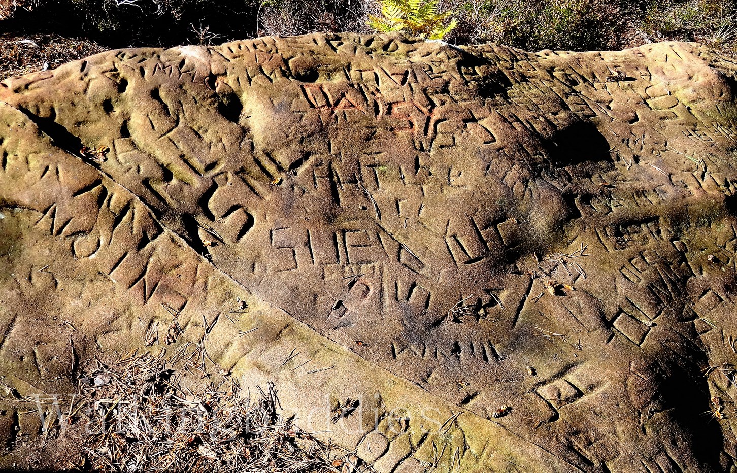
Oliver’s Point is supposedly named after Oliver Cromwell (him from the English Civil War). His men may have used the place as a lookout post and rumour has it they made the round holes in the rock to secure their cannons. Much more recent but not less interesting is all the graffiti in the sandstone rock….


When its time to move on, take the path left (following the cliff-edge on your right), slightly downhill through rhododendrons (and the ramparts) and you will come to a clearing with a few picnic tables. This area is known as ‘The Tea Tents’ as back in the day, there were wooden structures (pavilions) where people held tea dances. Apparently there was also a maze and they held archery competitions. Sadly the pavilions and maze are long gone.
CAVE
The footpath continues to follow the cliff edge and you will see a fence in places. After about 400m you will see the path and fence turning right as it follows steps carved in the rock down the cliff. It can be very slippery and there is an alternative a little further on but this involves climbing down some rocks.
A third alternative is to carry on all the way to the end and then turning right and doubling back. The fenced steps are probably the best option. At the bottom turn left for the cave.
The area around Nesscliffe was notorious for highwaymen in the 15th and 16th century. Legend tells us that Wild Humphrey Kynaston lived in the cave on Nesscliffe Hill and lived the life of a Robin Hood, robbing to help the poor. He was on the run for being accused of a murder elsewhere in the county. Humphrey was eventually pardoned in 1516 and died of natural causes in 1534.


 The interpretation board by Kynaston’s Cave says that it was lived in until at least the 18th century when a family of nine lived here. As you walk around you can see evidence of holes possibly used for posts and rails. With a little imagination a small camp or homestead soon takes shape.
Sadly, there is no access to the cave now, or even the steps to peer inside but that is because three species of bat are known to inhabit the cave now; pipistrelle, daubenton’s and Natterer’s.
Carry on by joining the bridleway which skirts the bottom of the cliff (turning left).
QUARRIES
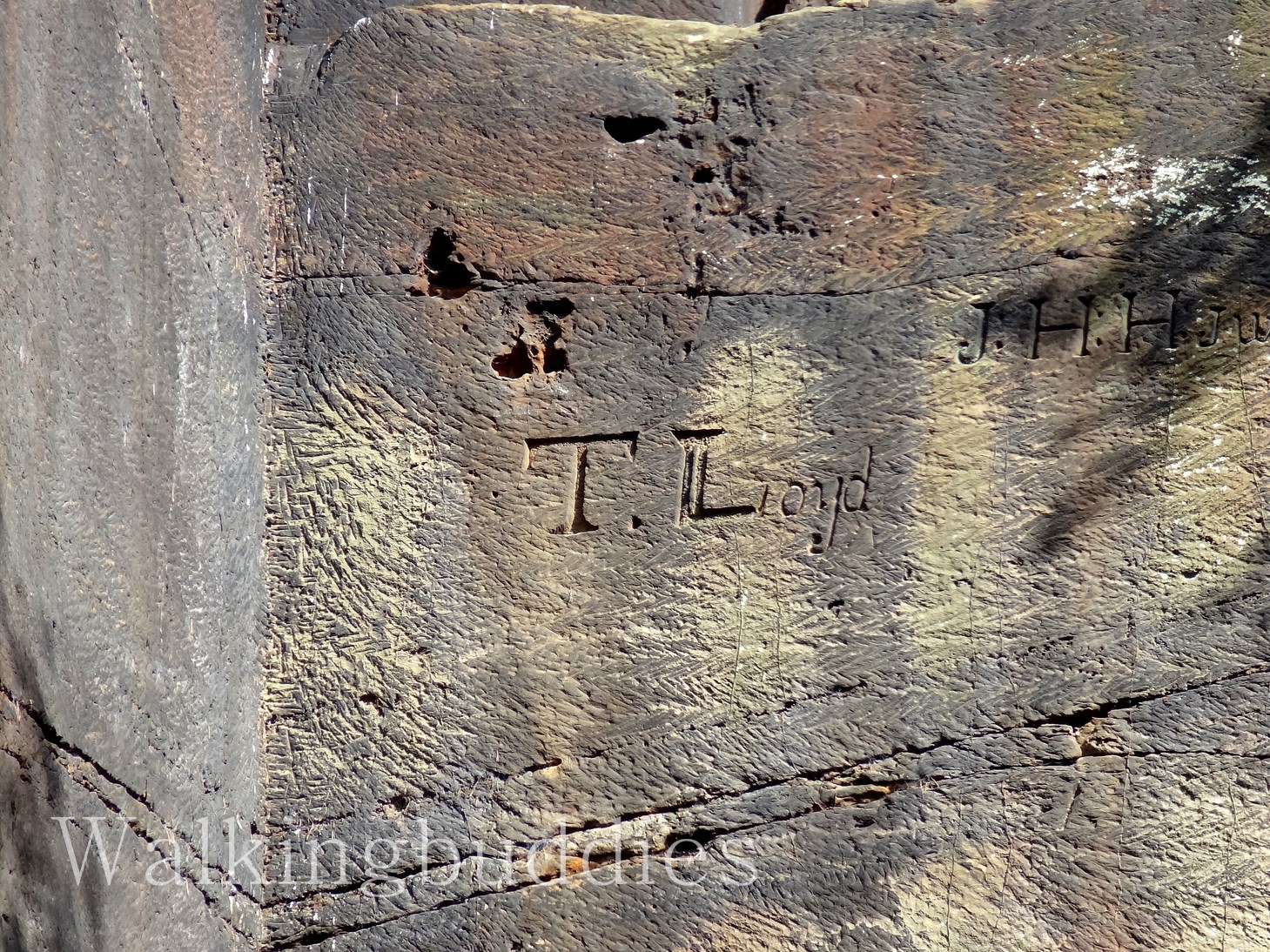
There are several quarries on Nesscliffe Hill and on The Cliffe. These were active until about 100 years ago. Now they are used for climbing and the chalk trails around finger holds gives a clue to some popular routes. One impressive quarry is just next to the cave. Guarded by a gate (without a fence). Look for the fascinating scratch graffiti high up on the cliff face. Who is T Lloyd? Were these initials carved by climbers or do they really date from 18xx as one of the carvings seems to suggest?

Carry on by joining the bridleway which skirts the bottom of the cliff (turning left). Go through the gate at
Hill Cottage and turn left up the lane. After a few metres take the footpath on the right and follow it through the wood
with a field on your right. On leaving the wood, cross the field keeping the hedge on your right until you get to the road. Go straight over and turn left at the signpost into the field. Carry on along the hedge at first, then to the top of the field, through the kissing gate and into the Pine Car Park.
THE CLIFFE
Turn right on the bridleway (nice wide track). After a short distance the bridleway bends left and a footpath is signed leading off to the right. Follow it down hill and then turn left down the track past Mount View until you get to the road. Go straight over. This was Hopton Hill.
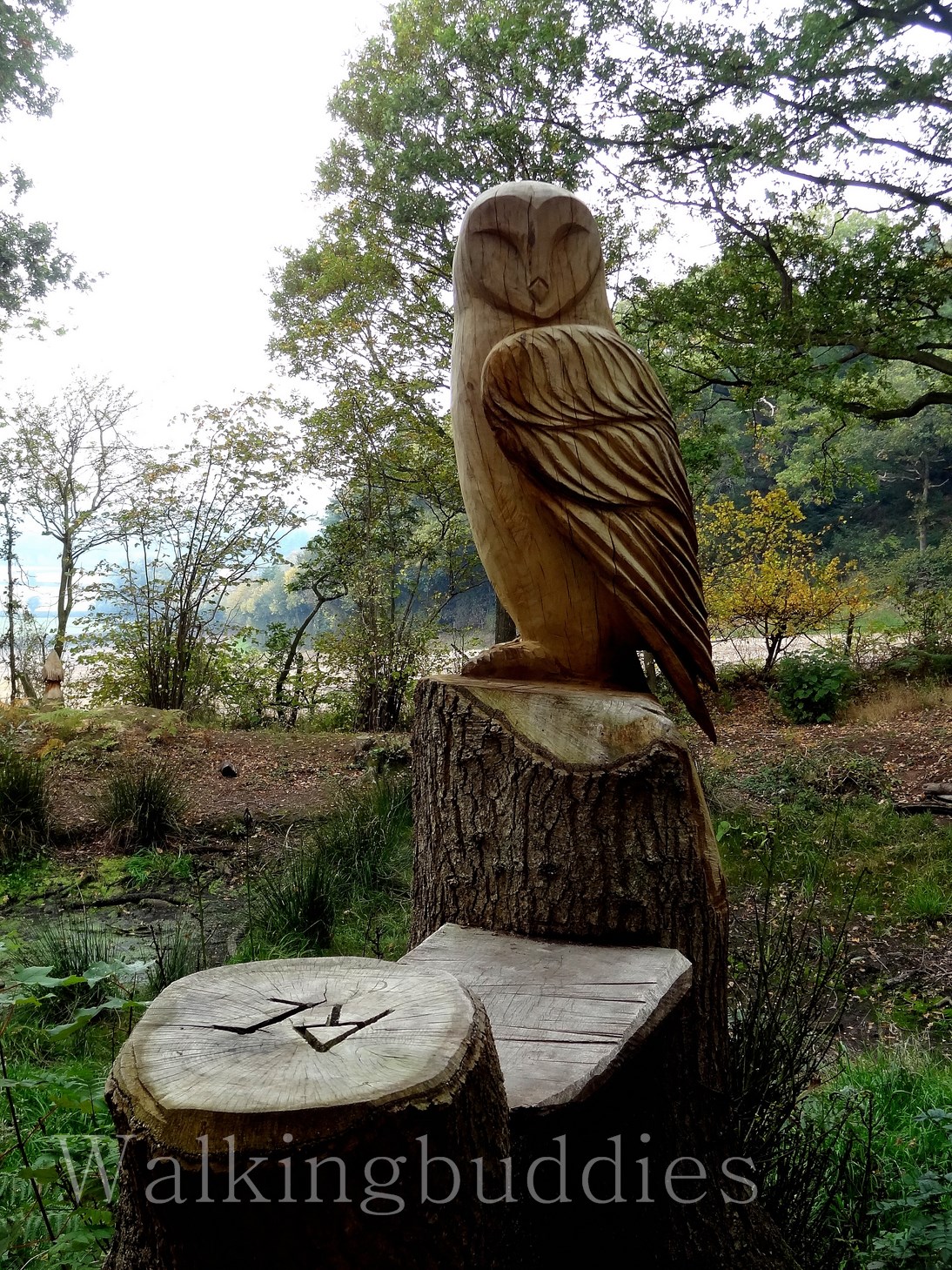
You w ill come to a small pond with some enchanting tree trunk skulptures (a frog, and owl and a grumpy looking bird of pray). Now this walk can be extremely muddy after prolonged wet weather. However, after a particularly dry spell, this pond will be a mud bath!! Either way, beware 🙂


BYGONE COTTAGES
Follow the path as it skirts the pond left and carries on along the field boundary. Follow this bridleway which runs along the bottom of The Cliffe. Look out for the remains of a few old cottages hacked into the sandstone cliff face on your right. Fascinating place to dwell a little.


Depending on time turn up hill opposite Ivy Cottage or carry on a few hundred yards further to the crossroads of paths/lanes and then turn up hill and fork left at the last house to get to the top of the ridge.
VIEWS
The ridge has a very different feel to the woodland you have been walking trough so far. It is exposed heath land with stunning views to both sides. There are several benches and they look well used and I can see why. Many local peaks can be seen, the Breidens straight out in front, the Lawley and Caradoc a little further over. The Arran and Breidden mountains on the other side and also of course the Wrekin. There is supposed to be a topograph (one of those plaques which tells you which peak is which) but I didn’t come across it. I think its because I stayed too high. I passed over the top, with the reservoir to my right. If you keep the reservoir on your left (cross below it) you will get to it! If you do take the route I did, there is a sign for ‘viewpoint’ on the far side of the reservoir (near the picnic table and information board), go down there and you will come across the plaque.


Turn you back on the Breidens view and follow the path down, beware it is rough with large slabs of stone and loose sand. Bear right and you will come out by the pool with the wood sculptures. Go straight across the road and retrace your steps trough Hopton Hill wood to the Pines car park area. Cross the lane and take the footpath back down to the wood and retrace your steps from the start of the walk back past the hill fort and to the Oaks Car Park.
